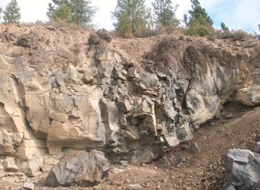
Farallon conducted a subsurface investigation at an abandoned quarry to determine whether sufficient bedrock remained to reopen the quarry. Following Farallon’s explorations, the county wanted to mine the bedrock to provide aggregate rock for planned road construction in the area, saving transport time and money.
Farallon performed a soil and bedrock delineation at the quarry to discover whether sufficient bedrock remained for the county to pursue negotiations to lease the quarry from the U.S. Forest Service. Of the approximately 8-acre quarry, the county asked Farallon to designate an area of less than 5 acres for potential mining.
Farallon confirmed that sufficient bedrock remained in the quarry for the county to pursue acquiring a permit to negotiate a lease to reopen the quarry. The excellent quality of the volcanic bedrock was preferred for use as road base and the quarry’s prime location near the construction area resulted in a shorter material hauling distance, saving the county time, fuel, and money.
To determine the thickness of the bedrock and identify the best area for potential mining, Farallon drilled 19 exploratory borings from 40 to 67 feet below ground surface using air rotary drilling methods. A Farallon Scientist logged the lithology of each boring during drilling that consisted of volcanic soils with tephra deposits, pumice, cinders, welded tuff, and volcanic bedrock identified as basalt, and andesite. The thickness of the volcanic bedrock was measured at each location on a grid system across the quarry to get a three-dimensional picture of the bedrock remaining underground.
“The U.S. Forest Service trusted our methodology and results, and we were able to alleviate their concerns about reopening the quarry,” said Project Scientist Ken Scott, who performed the bedrock delineation. “Through Farallon’s excellent working relationship with the U.S. Forest Service, we were able to help our client evaluate the bedrock remaining in the quarry in a cost-effective manner.”

